The WorldTour stage race Paris–Nice will take place from March 8 to 15, 2026. It consists of eight stages with a total distance of 1,245 kilometers and 16,460 meters of altitude. The 23.5-kilometer team time trial and the last two stages in the Maritime Alps promise particular excitement. First, the mountain finish in the winter sports resort of Auron is on the program on Saturday, and on the final day, the mountainous stage around Nice. Alpecin Cycling presents the eight stages in more detail.
Map: The route of Paris – Nice 2026
1st stage | March 8 | Achères – Carrieres-sous-Poissy | 171.2 km | 1,950 m elevation

Paris–Nice does not start with a flat “roll-in”. The first stage from Achères to Carrières-sous-Poissy ends on a circuit on which the Côte de Chanteloup-les-Vignes is ridden twice in the last 40 kilometers. Although the climb is only 1.1 kilometers long, it climbs at an average of 8.3 percent. This is ideal for puncheurs, but suboptimal for the sprinter teams who want to get over it in an orderly fashion. However, it is a good ten kilometers from the last passage of the Côte de Chanteloup-les-Vignes to the finish.
2nd stage 2 | March 9 | Épône – Montargis | 187 km | 1,270 m elevation
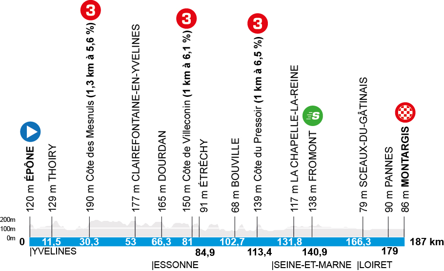
Despite three categorized climbs, this seems like a good day for the sprinters. And probably the only one in the race to the sun. After the start in Épône, the riders have to overcome three short waves: Côte des Mesnuls (1.3 kilometers at 5.6 percent), Côte de Villeconin (1 kilometer at 6.1 percent) and Côte du Pressoir (1 kilometer at 6.5 percent). From the last Côte to the finish in Montargis it is then still over 75 kilometers, in which the sprinter teams can bring back the breakaway riders. Only possible crosswinds in the open terrain could thwart the plans of the fast and explosive men. The classics riders would be happy about such a scenario.
3rd stage | March 10 | Cosne-Cours-Sur-Loire – Pouilly-Sur-Loire | 23.5 km / TTT | 240 m elevation
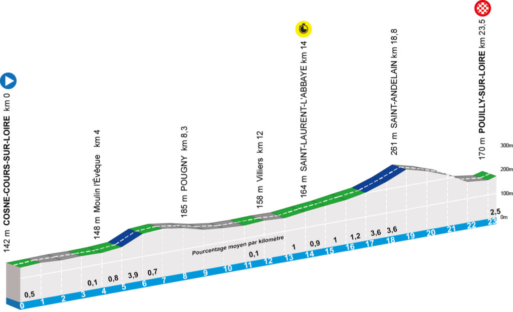
This is, so to speak, the dress rehearsal for the opening stage of the Tour de France in Barcelona is the third stage of Paris–Nice. A 23.5 kilometer long team time trial from Cosne-Cours-sur-Loire to Pouilly-sur-Loire. As with the Tour de France in July, the time will not be counted after the fourth rider, but each rider will be stopped individually. This lead-out mode was already tested at Paris–Nice a year ago.
After this team time trial, there will not be too big gaps among the top riders in the overall standings. Nevertheless, it will sort the classification and create a certain hierarchy. The performance managers of the teams will certainly spend a lot of time analyzing this stage afterwards.
4th stage | March 11 | Bourges – Uchon | 195 km | 2,520 m elevation
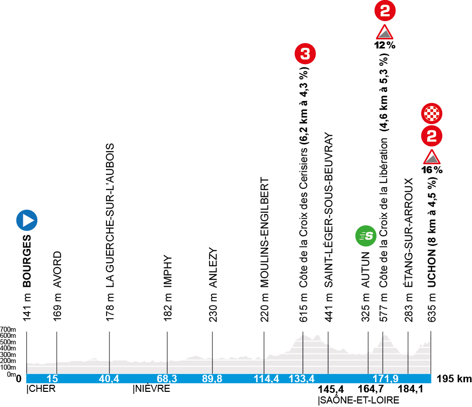
The team time trial is followed by the first mountain finish of this tour – up to Uchon. After the start in Bourges, the first 120 kilometers are flat. Only then does the terrain become challenging: The start is made by the Côte de la Croix des Cerisiers. A 3rd category climb with a length of 6.2 kilometers and an average gradient of 4.3 percent. Once this climb has been completed, the final begins around 30 kilometers later with the Côte de la Croix de la Libération – 4.6 kilometers with a 5.3 percent gradient. However, there are sections with gradients of up to 12 percent.
After a descent and a short flat section, the eight-kilometer final climb to the stage finish in Uchon begins. The stated average gradient of 4.5 percent does not reflect the actual difficulty. Because the climb is very arrhythmic with ramps of up to 16 percent.
5th stage | March 12 | Cormoranche-sur-Saône – Colombier-Le-Vieux | 205.4 km | 3,020 m elevation
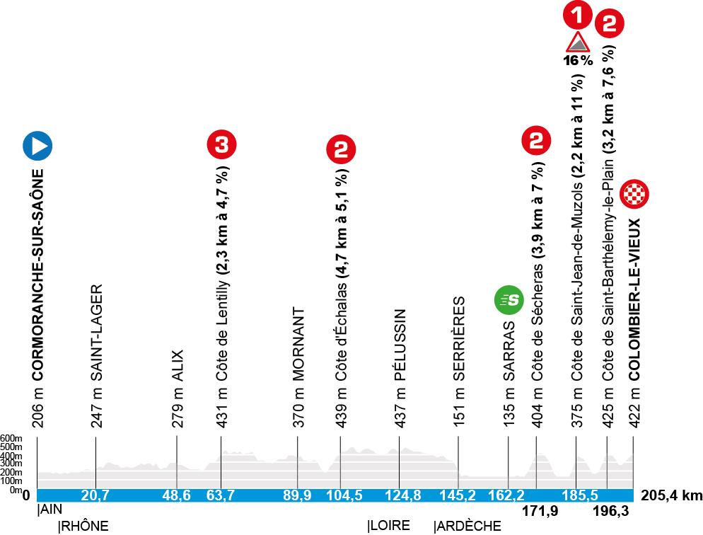
At 205.4 kilometers, this is the longest stage, which takes the riders further and further south. The start is in Cormoranche-sur-Saône, the finish is in Colombier-le-Vieux in the Ardèche. This is suitable terrain for puncheurs to test themselves, but also the competition. Because in addition to the five categorized climbs, the profile is very undulating, so that in the end more than 3,000 meters of altitude are added up.
The start to the “Côte-Hopping” is made after a good 60 kilometers with the Côte de Lentilly (2.3 kilometers with a 4.7 percent gradient). 40 kilometers later follows the Côte d’Échalas (4.7 kilometers with a 5.1 percent gradient). Then there is a short “rest” before the final storm. In the last 40 kilometers there are three categorized climbs and a mountain finish to Colombier-le-Vieux. The start to an elimination race is made by the Côte de Sécheras (3.9 kilometers with 7 percent). At a distance of 10 to 12 kilometers each, the Côte de Saint-Barthélemy-le-Plain (3.2 kilometers with 7.6 percent, maximum 16 percent) and the Côte de Saint-Jean-de-Muzols (2.2 kilometers with 11 percent) follow. After a short descent, the approach to the finish begins.
Even if the terrain does not pose too great problems for the general classification riders, they must be well positioned in the final in order not to lose contact.
6th stage | March 13 | Barbentane – Apt | 179.3 km | 2,100 m elevation
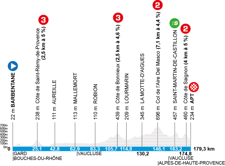
Again, it could be a day for punchers and classics-proof general classification riders, although the decision for the stage win could probably be made from a breakaway group. The 6th stage starts in Barbentane and ends after 179.3 kilometers in Apt.
The only challenge in the first 100 kilometers is the Côte de Saint-Rémy-de-Provence (2.5 kilometers with a 5 percent gradient). Then the professionals head for the Luberon. After almost 100 kilometers follows the Côte de Bonnieux (2.5 kilometers with 4.6 percent). Via Lourmarin and La Motte-d’Aigues, the professionals reach the foot of the Col de l’Aire Deï Masco. A 2nd category climb that is 7.1 kilometers long and averages 4.4 percent steep.
From the pass at 696 meters, the route leads downhill for a longer time, before a climb to the sprint classification to Saint-Martin-de-Castillon and then to the Côte de Saignon (4 kilometers with a five percent gradient) follows in the last 20 kilometers before the finish, which can decide the stage win.
7th stage | March 14 | Nice – Auron | 138.7 km | 2,850 m elevation
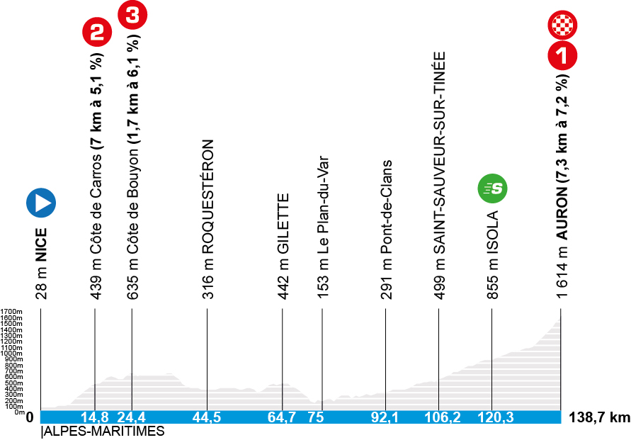
Upside down world at Paris-Nice 2026: The famous Promenade des Anglais is not the finish of the final stage this year, but the start of the penultimate stage. The reason for this are the local elections taking place on Sunday.
From Nice, the route leads towards the Maritime Alps. Early in the stage, Côte de Carros (7 kilometers with 5.1 percent) and Côte de Bouyon (1.7 kilometers with 6.1 percent) have to be climbed. After that, the terrain “calms down” and there is a long run-up towards the mountain classification. This begins after the sprint classification in Isola.
The 1st category climb is over 7.3 kilometers long, averages 7.2 percent steep and leads up to the winter sports resort of Auron at an altitude of 1,614 meters – also the roof of Paris-Nice. It is questionable whether there will be a classic elimination race here or whether the climb is too short and not selective enough, so that the best come to the finish line in a small group.
8. Stage | March 15 | Nice – Nice | 145 km | 2,780 m elevation
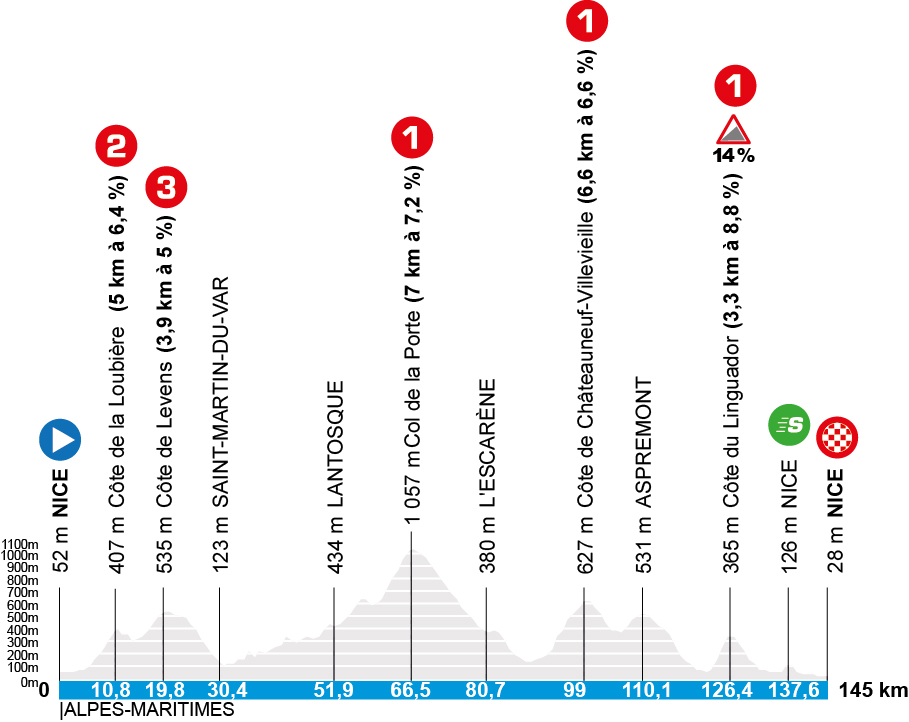
As almost always at Paris-Nice, the final day has it all. A 145 kilometer long, selective loop around Nice offers the riders numerous opportunities to attack. A total of five categorized climbs have to be mastered, three of them of the first category. The only question will be at which Côte or which Col the race really escalates. Anyone who has big plans and has a strong team will have the Col de la Porte, which is located after around 60 race kilometers, pre-sorted. Although the first category climb is “only” seven kilometers long and has an average gradient of 7.2 percent. However, the road rises noticeably beforehand.
After a very long descent, which must be ridden accordingly offensively, the Côte de Châteauneuf-Villevieille (6.6 kilometers with a 6.6 percent gradient) could herald the final. However, the descent does not take place directly after the mountain classification, but after a small intermediate descent, the riders have to climb back up to Aspremont.
Only then does the stage lead downhill for a good 12 kilometers and almost immediately into the last mountain of the day and this tour. The final decision on the stage win and/or overall success could be made on the Côte du Linguador. It is not particularly long at 3.3 kilometers, but the 8.8 percent on average with ramps of 14 percent are ideal to break away. After the approach, the course continues via the sprint classification in Nice at race kilometer 137.6, before the finish is reached at the Stade Riviera.
Profiles: © A.S.O.
Map: © GEOATLAS
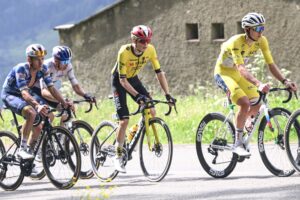
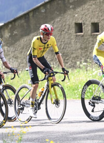
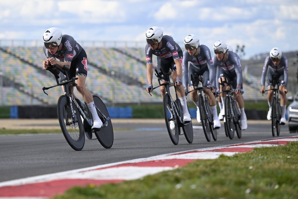
Photo: IMAGO / Photo News