
This is where this year’s Tour de France will lead pro riders to. An overview of all 21 stages with altitude profile and short description.
The 21 stages of the 108th Tour of France promise a lot of excitement and variety. 8 flat stages, 5 hilly sections, 6 mountain stages and 2 time trials are on the programme between the start in the city of Brest and the arrival in Paris. In total, the peloton is going to ride 3383 kilometres between 26 June and 18 July. Please find below an outline of all stages:
Stage 1 | 26 June | Brest – Landernau | 197.8 km
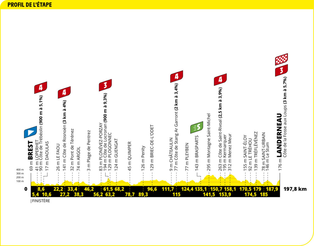
The first stage leads from the harbour town on the Atlantic to Landerneau – over 197.8 kilometres and a total of six mountain classifications. Though they are only classified categories four and three, they will probably quickly be too much for top sprint specialists. Especially as they will have to climb 3.7 km with an average gradient of 5.7 percent to get to the finish: the Côte de la Fosse aux Loups which comes up with yet another challenge – right at the beginning of the climb there is a steep 14-percent section that will suit puncheurs particularly well.
Stage Preview with Lude and Schmitti
Map of the 1st stage of the Tour de France 2021
Stage 2 | 27 June | Perros-Guirec – Mûr-de-Bretagne Guerledan | 183.5 km

Stage 2 leads the riders to Mûr-de-Bretagne. In this Breton municipality they will have to climb a 2 km ascent with an average gradient of 6.9 percent. Again, a finish climb that should accommodate GC riders and climbers. At the last finish there in 2018, they took the top 15 places in the stage rankings – with two exceptions: Julian Alaphilippe and Peter Sagan.
Stage Preview with Lude and Schmitti
Map of the 2nd stage of the 2021 Tour de France
Stage 3 | 28 June | Lorient – Pontivy | 182.9 km

On day three of the 2021 Tour de France, however, it will most likely be the sprinters who will be the first to push their front wheels over the finish line. This is, because the stage from the harbour town of Lorient to Pontivy has hardly any topographical difficulties and an easy final stretch.
Stage Preview with Lude and Schmitti
Map of the 3rd stage of the 2021 Tour de France
Stage 4 | 29 June | Redon – Fougères | 150.4 km

Not a single mountain classification appears on the profile of stage four. From Redon to Fougères, the route leading through Brittany towards the heart of the country is flat. After 150.4 kilometres and less than four hours of racing, the top sprinters will fight for the stage win in a sprint royale.
Stage Preview with Lude and Schmitti
Map of the 4th stage of the Tour de France 2021
Stage 5 | 30 June | Changé – Laval | 27.2 km

Those who are neither time trial specialists nor aim for the general classification will have (half) a rest day today. This is what the riders themselves call the days of a Grand Tour when they individually battle against the clock. The individual time trial is 27.2 kilometres long and may have a big impact on the overall standings, as there may be minute gaps between the riders aiming for the overall win due to the stage’s length.
Map of the 5th stage of the Tour de France 2021
Stage preview with Lude and Schmitti
Stage 6 | 1 July | Tours – Châteauroux | 160.6 km

The famous castles of the Loire are probably the most interesting thing to watch in the first part of the stage. The second part is about catching the escapees and preparing for a bunch sprint in Châteauroux after less than four hours of riding.
Map of the 6th stage of the 2021 Tour de France
Stage preview with Lude and Schmitti
Stage 7 | 2 July | Vierzon – Le Creusot | 249.1 km

The longest stage of this Tour and of the past 21 years. Not only do the riders have to face an impressive 249.1 kilometres there are also three climbs on the last 40 kilometres. The most difficult and the last chance to bring about a decision is the Signal d’Uchon with a length of 5.7 kilometres and an average gradient of 5.7 percent.
Map of the 7th stage of the Tour de France 2021
Stage preview with Lude and Schmitti
Stage 8 | 3 July | Oyonnax – Le Grand-Bornand | 150.8 km

The Tour reaches the Alps and Le Grand-Bornand, a popular start and finish destination of the Tour. To get there, organisers chose the difficult option – at least as far as the second part of the stage is concerned. Riders will first have to climb Côte de Mont-Saxonnex followed by the tough combo of Col de Romme and Col de la Colombière before they enter the descent to Le Grand Bornand. The last two climbs and the final 40 kilometres of the short mountain stage are identical to the section of 2018, which Julian Alaphilippe won as a soloist.
Map of the 8th stage of the 2021 Tour de France
Tour preview with Lude and Schmitti
Stage 9 | 4 July | Cluses – Tignes | 144.9 km

Stage 9 starts in the same place where the peloton set off for the first of the two final climbs in the previous stage – in Cluses. The stage is short, but the time gaps that the first mountain finish of this Tour could cause will probably be big. The route is scenically beautiful and leads over Col du Pré to Cormet de Roselend and its lake. The long final climb up to the winter sports resort of Tignes on a large wide road is no scenic treat, however.
Map of the 9th stage of the Tour de France 2021
Stage 10 | 6 July | Albertville – Valence | 150.7 km

Out of the Alps and into Provence region – that’s were today’s 190.7-kilometre transfer stage leads to. There are hardly any difficulties on the way from the Olympic city of Albertville to Valence – which is also called the gateway to Provence. Exception: an uncategorised climb at kilometre 150, where a few sprinters who might be a little tired after the Alps and failed to recover on rest day could fall behind if the speed ridden is high.
Map of the 10th stage of the Tour de France 2021
Stage 11 | 7 July | Sorgues – Malaucène | 198.9 km

The peloton climbs the white giant of Provence – the Mont Ventoux – twice today. First the route leads riders via Sault in the southeast to the summit. The descent brings them down to Malaucène before the classic route via Bedoin and the Chalet Reynard leads them back up to this mountain of destiny. This year, the race won’t end at the top, but only after the descent to the finish town of Malaucène.
Map of the 11th stage of the 2021 Tour de France
Stage 12 | 8 July | Saint-Paul-Trois-Châteaux – Nîmes | 159.4 km

Only a few kilometres after the start, the route leads along the breathtaking ravines of Gorges de l’Ardèche. Then the route drifts south and sets course for the ancient Roman city of Nîmes with its well-preserved Colosseum. Although the stage looks easy on paper, the wind in the Rhone Valley may become a factor of influence and there will be fierce battles for positions well before the finish.
Map of the 12th stage of the 2021 Tour de France
Stage 13 | 9 July | Nîmes – Carcassonne | 219.9 km

The second longest stage of this year’s Tour of France seems to be cut out for the sprinters. The only elevation is to be found at kilometre 51.5 with the Cote du Pic Saint-Loup the rest of the stage to Carcassonne is rather flat. However, no stage has ever ended in a bunch sprint there, but it has always been small groups or solo riders that have reached the finish first. Will there be a novelty in Carcassonne after almost 120 years of the Tour de France?
Map of the 13th stage of the 2021 Tour de France
Stage 14 | 10 July | Carcassonne – Quillan | 183.7 km

Even though there aren’t any first or hors category climbs on this stage, an exciting battle for the overall classification might take place as the profile is tempting to try for some targeted escalation from the middle of the stage on. From the Col de Montségur onwards, the course will be a continuous up and down, what will make it difficult for the big teams to control the race until the finish. Furthermore, the bonus seconds that will be awarded on the last climb shortly before the finish will make being in the front even more attractive.
Map of the 14th stage of the 2021 Tour de France
Stage 15 | 11 July | Céret – Andorra-la-Vieille | 191.3 km

The 15th stage leads across the roof of the Tour to the stage finish in the principality of Andorra. Port d’Envalira at 2408 meters is the highest point of the Tour of France. But the climbing does not end there. After a descent, the course leads up to Col de Beixalis, a steep climb with many hairpin bends, from the top of which the road runs downhill again to the finish in the city of Andorra.
Map of the 15th stage of the 2021 Tour de France
Stage 16 | 13 July | Pas de la Case – Saint-Gaudens | 169 km

After the rest day, the route planners show some mercy this year. Unlike in 2016, for example, when the stage started from the city of Andorra, and riders had to climb Port d’Envalira from the other side. Instead, the stage begins in Pas de la Case on the Andorran-French border and first leads downhill for about 35 kilometres before it the route becomes more difficult with four climbs until the finish line in Saint-Gaudens. Unless riders have a “jours sans” – a bad day – they will get through this stage without any problems.
Map of the 16th stage of the Tour de France 2021
Stage 17 | 14 July | Muret – Saint-Lary-Soulan Col du Portet | 178.4 km

On Bastille Day, France’s national holiday, not the Bastille will be stormed, but the Pyrenean summit Col du Portet at the end of the stage. It is the second mountain finish of this Tour, the highest asphalted pass in the French Pyrenees and the final climb after Col de Peyresourde and Col du Val Louron-Azet.
Map of the 17th stage of the 2021 Tour de France
Stage 18 | 15 July | Pau – Luz Ardiden | 129.7 km

The third and last mountain finish of this Tour offers strong climbers who aim at the mountains classification a good opportunity to attack. The section over Col du Tourmalet and up to the finish in Luz Ardiden is only 130 kilometres long. Riders who want to make up time, will have to go on the offensive at the mythical Tourmalet.
Map of the 18th stage of the 2021 Tour de France
Stage 19 | 16 July | Mourenx – Libourne | 207 km

A 207-kilometre stage awaits the riders on this day. The topography predestines it for a sprint final. But which sprinters will still be in the race at this point and manage to control the stage to Libourne with their teams? Maybe the chance for an escape attempt after all…
Map of the 19th stage of the Tour de France 2021
Stage 20 | 17 July | Libourne – Saint-Emilion | 30.8 km

The second time trial of this Tour of France leads 31 kilometres through the vineyards near Bordeaux. For specialists who can push hard for a long time, this is an almost ideal setting. The rather lightweight GC riders with strong climbing skills will need to make sure not to forfeit their ranking in the overall classification.
Map of the 20th stage of the 2021 Tour de France
Stage 21 | 18 July | Chatou – Paris | 108.4 km

Overall leaders will adhere to the no attacks rule of the “Tour d’Honneur” – as the final stage is called in honour of the yellow jersey –, for the sprinters it is all about the most prestigious stage win of the Tour on the Champs-Elysees – and maybe also about winning the green jersey of the points classification.
Map of the 20th stage of the 2021 Tour de France
Profiles of the Stages: ©A.S.O.
Maps of the stages: ©GEOATLAS


